MAPPING A BURIED WATERWAY
This project was birthed during a Landscape Systems course that combined GIS
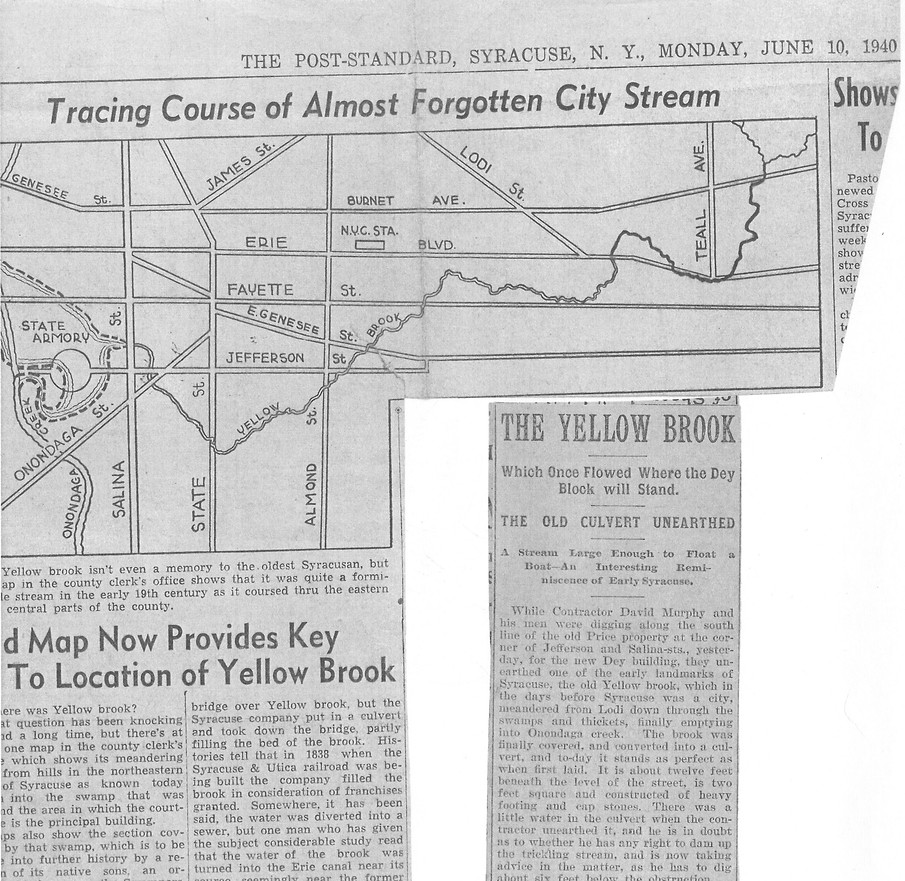
mapping technology and landscape systems thinking. I stumbled upon historic Yellow Brook during a hunt for historical information on S. Salina Street for a different project. A tattered newspaper article highlighted a once vibrant flowing brook, now buried.
This piqued my interest since I had just recently learned about daylighted rivers and streams during the Landscape Systems course. I decided to ask if the Onondaga Historical Society had an entire file on Yellow Brook by any chance. They proceeded to hand me a file with many more news articles and spoken/written accounts about the history of Yellow Brook's flow, it’s life and its eventual ‘death’, buried, yet often dug into, accidently released during construction or accidental street cave in’s.
I felt called to visualize and spatialize these historical written accounts and find out where the suspected Yellow Brook once flowed, overlayed with current mapping GIS data sets in hopes to discover if there are any remnants of this historic waterway lurching in present day GIS data layers. As well as creating my own data layers based on the historical accounts of the flow pattern.
DATE
FALL 2024
PROJECT LOCATION
YELLOW BROOK (HISTORICAL MAPPING, NOW A BURIED WATERWAY)
PROGRAMS + TOOLS USED
HAND DRAWING, PENCIL, MAPPING, HISTORICAL ARCHIVE RESEARCH
GIS SOFTWARE, PHOTOSHOP, ILLUSTRATOR
LEARNING OUTCOMES
TO PRACTICE GIS AS A TOOL FOR VISUALIZING CRITICAL
INFORMATION TO STAKEHOLDERS AND THE PUBLIC. UNDERSANDING
DIFFERENT CAPABILITIES OF GIS AND HOW THAT INFORMATION
CAN BE USED, LAYER AND TELL A STORY BASED ON DATA.

Yellow Brook
A once meandering and lush waterway that flowed through the City of Syracuse.
Officially buried in 1838 by Syracuse and Utica Railroad Co.
They were to finish filling in this waterway as part of the rights agreement for their ownership.
"In some cities,
more than
of streams
have been paved over.
In many cases, city residents don't even know that there are buried waterways under their feet."
- Rachel Kaufman,
National Geographic 2013
1940 Syracuse Post Standard News Clipping
70%
GIS Data | Spatialized Results

I stumbled upon historic Yellow Brook during a hunt for historical information on S. Salina Street for a studio assignment this semester. A tattered newspaper article highlighted a once vibrant flowing brook, now buried. This piqued my interest since we had just recently learned about daylighted rivers and streams. I decided to ask if OHA had an entire file on Yellow Brook by any chance. They proceeded to hand me a file with many more news articles and accounts about the history of Yellow Brook, it’s life and its eventual ‘death’, buried, yet often dug into or accidently released during construction or accidental street cave in’s. I would need to research and interview locals to understand if Yellow Brook still makes any appearances today in basements or foundations on rainy days. Although if it is moving along in a sewer now, I imagine the one free flowing brook is highly contained and controlled.
This assignment showed me that the historical written accounts I gathered from the OHA archives in Syracuse, NY, mapped nearly perfectly with the present day visual map. The suggested pathways I traced based on historical accounts highlighted a number of variations from where people believed it originated and the twists and turns it took to get to Onondaga Creek via the Old Mill Pond. The sewer line data and the flood risk data both indicated a number of things. The (orange) sewer lines route below and around where the historical tracings of Yellow Brook likely flowed, indicated that the water could to this very day, be flowing through a sewer, because the account that said they routed it into the Erie Canal wouldn’t make any sense now, since the Lodi Locks, at the corner of Lodi Street and Canal Street have long since disappeared.
The flood risk data indicates a bright blue polygon around the area where Yellow Brook would have likely met Old Mill Pond and dumped into Onondaga Creek, meaning higher flood risk. These moments indicate to me that the historical data, along with current digitized GIS data, seem to have some correlations happening. Although much of the data pursued did not directly help this project, some of what I found supports the historical accounts of flow patterns. E Water Street was likely named this way because Yellow Brook historically flowed along E Water Street. It has also helped me understand more about our city, and where I live, which is very close to the Lodi Hills, in walking distance of where the old Lodi locks once were.
The 1’ topography layer was not incredibly helpful since it is not historic topography, I would have needed topography prior to 1838 and that wasn’t a realistic thing to find. I also pulled Lidar data as well, which again helped with building the topography lines, however was not historically helpful. If I could continue to dissect and learn about Yellow Brook, I would pursue what the buffer zone would be like in terms of physical size/width. You had mentioned/asked: “deciding what impacts daylighting would have would require you to identify the spatial characteristics of daylighting a stream - how wide does the streambed need to be? You could create a buffer around one of the historic paths that estimates how much land you would need, but you would first have to find a precedent of a daylighted stream to estimate how wide this buffer should be.” This does interest me, however with the amount of infrastructure built up in the city, I’m not sure what form Yellow Brook would be able to take let alone where it is even flowing anymore.