SOURCESCAPE
This planting design course guided us through a variety of prompts during the semester, the first two projects led us to the final prompt which was a culmination of all the previous work at the same site as we worked to produce a comprehensive design and program for our chosen vacant site within the Northern quadrant of the City of Syracuse.
DATE
FALL 2024
PROJECT LOCATION
WATER STREET CORRIDOR, DEACTIVATED CORNER LOT
OWNER: UPSTATE MEDICAL CENTER
NORTHERN QUADRANT OF CITY OF SYRACUSE
PROGRAMS + TOOLS USED
HAND DRAWING, PENCIL/PEN, COLORED PENCIL, MODEL MAKING
DIGITAL CAMERA, EXCEL, AUTOCAD, ILLUSTRATOR, PHOTOSHOP,
LEARNING OUTCOMES
TO PUT PLANTING DESIGN CONCEPTS AND CHANGE OVER TIME CONSIDERATIONS INTO PRACTICE. TO ACKNOLWEDGE THE COMPLEX
RELATIONSHIPS, NUANCES OF PLANTING DESIGN CHOICES, AND BEGIN TO UNDERSTAND THAT UNDERSTANDING THIS WELL WILL LIKELY TAKE YOU THE REST OF YOUR CAREER.
PLANTING DESIGN PROMPT | P01 DIDACTIC GROUNDS
VACANT, WILDSCAPE (WOULD LATER BECOME A PARKING LOT.)
WATER STREET CORRIDOR
SYRACUSE, NEW YORK 13210


PLANTING DESIGN PROMPT | P02 MARGINAL GARDENS
LOCATION
VACANT, WILDSCAPE (WOULD LATER BECOME A PARKING LOT)
WATER STREET CORRIDOR
SYRACUSE, NEW YORK 13210


MODEL MAKING ROUND 1 | Individual Assignment
This model highlights the area of the design by the existing walkway and stone retaining wall that had slowly been covered by dirt, debris and overgrowth of invasive species. By uncovering this, exposing the history and the beauty of these hardscape elements, it is then contrasted by a bioswale area that is planted with trees, shrubs and grasses that work with and extenuate the natural topography of the earth, allowing water to flow and absorb into the earth while nourishing these plantings, creating a cool, peaceful habitat for urban wildlife and a reprieve for people living and working nearby from the harsh, hot and noisy urban landscape that surrounds this focus site on all sides.


PLANTING DESIGN PROMPT | P03 LOST SITES
PROJECT
SOURCESCAPE | COLLABORATION WITH IZ ZAYAS
LOCATION
VACANT, WILDSCAPE (WOULD LATER BECOME A PARKING LOT)
WATER STREET CORRIDOR
SYRACUSE, NEW YORK 13210
The content below shows pages from our final booklet, and additional process photos and related content between pages to show how we arrived at the design rationale that we did as a team, working on all aspects of this project together. It was a true collaboration and work of magic.


This initial co-drawing highlights the overall design concept and site layout.

This initial co-drawing highlights solar input patterns and suggested soil typologies.
PLANTING PLANS AND SECTION VISUALIZATIONS
These planting schedules and corresponding sections represent our planting design as it changes through time.
YEAR 01 | SEEDED


YEAR 05 | BLOOM


YEAR 10 | FLORA FLOURISH


MODEL MAKING WITH MATERIALS FROM THE LANDSCAPE
This process made the graphics you see below possible. IZ and I chose not to 3D model this vision, and instead use 100% natural materials, (the entire model can be burned safely) and materials from the landscape to inform our idea and how it might function in a spatialized and embodied way. It was late fall early winter at this time, and I went out into the landscape to gather plants and their dried seeds and interesting structures and shapes to become the structures that would build the spatial qualities of the base which included our ground level materials; sand, stone tile pavers, and cobble.


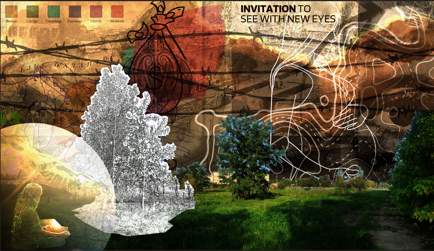
SYNTHESIS COLLAGE OF SITE HISTORY, MEMORY, LANDSCAPE, ERASURE, OWNERSHIP
CHANGE OVER TIME Images of the project site through the seasons and ongoing development

WILDSCAPE
Early Fall 2024
This site was vacant for many years after a housing complex was removed. This space was able to repopulate with species that thrive on disturbance laden land, poor, damaged, and depleted soils created this wildscape the way you see it in this photo. It was serene and truly beautiful the way it presented itself.

BEFORE
Fall 2024
A truly wild urban area, left to its own agenda for about 10-12 years.

